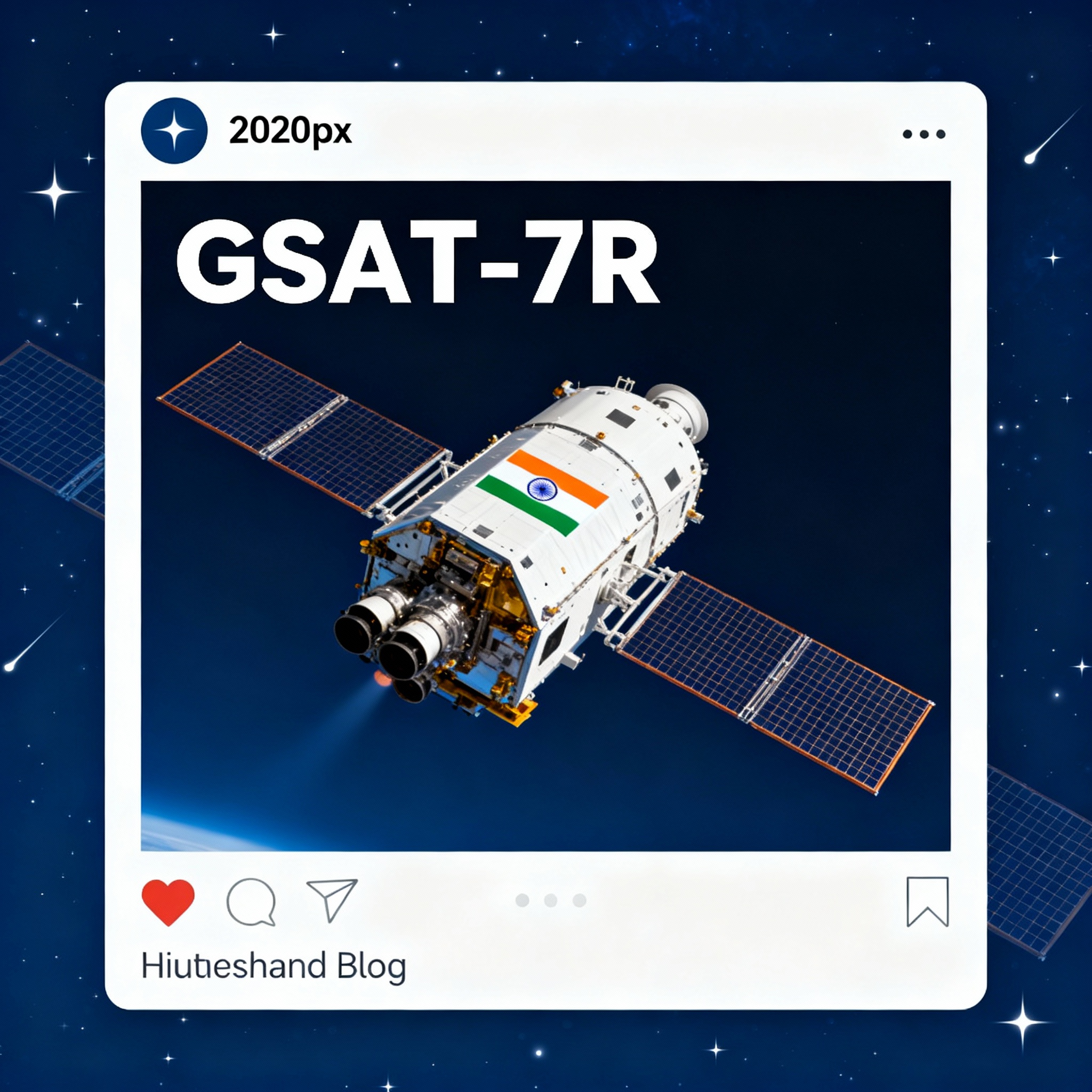
1. GSAT-7R, Indias heaviest communication satellite
Prelims: GS Paper-1 → Science & Technology (Space Missions, Defence Tech).
Mains: GS Paper-3 → Science & Tech (Indigenization), Security (Maritime Domain Awareness), Achievements of Indians in S&T.
Context: ISRO launched GSAT-7R, India’s heaviest communication satellite, for the Indian Navy.
- The launch strengthens India’s maritime domain awareness and defense capabilities.
About GSAT-7R (CMS-03)
- GSAT-7R is an indigenously designed and built communication satellite for the Navy.
- It weighs about 4,400 kg, making it the heaviest Indian communication satellite.
- It was launched by ISRO’s LVM3 rocket into geosynchronous transfer orbit (GTO).
Key Features & Technical Details
| Feature | Details |
| Satellite | GSAT-7R (CMS-03) |
| Weight | ~4,400 kg |
| Launch Vehicle | LVM3-M5 |
| Orbit | Geosynchronous transfer orbit (GTO) |
| Payload | Advanced transponders for robust communication |
| Launch Site | Satish Dhawan Space Centre |
| Date of Launch | November 2, 2025 |
Why It Matters for Indian Navy
- Real-time secure links: Ships ↔ Subs ↔ Aircraft ↔ Shore HQs.
- High-bandwidth: 5× more than GSAT-7 for video & data.
- All-weather, jam-resistant comms in contested IOR.
- Force multiplier for blue-water ops & carrier groups.
- Reduces reliance on foreign satcom (e.g., Inmarsat).
Technical Achievements
- 100% indigenous payloads & components.
- First 4+ tonne GTO launch from India.
- LVM3 injects 4.4 t to standard GTO (no foreign help).
- Advanced multi-band transponders + large deployable antennas.
- On-board propulsion for orbit raising.
Strategic Importance
- Dominates IOR: Counters China’s String of Pearls.
- Maritime Domain Awareness: Real-time tracking of 7,500+ km radius.
- Net-centric warfare: Enables tri-service integration.
- Deterrence: Secure C2 in Indo-Pacific flashpoints.
- Self-reliance: Cuts foreign satcom costs & vulnerabilities.
What is LVM3?
- Nickname: “Bahubali” – India’s heaviest rocket.
- Height: 43.5 m | Lift-off mass: 642 t.
- Stages: 2× S200 solid + L110 liquid + C25 cryogenic.
- GTO capacity: 4 t (upgradable to 7.5 t).
- Success rate: 8/8 missions (incl. Chandrayaan-3).
- Future: Human-rated for Gaganyaan.
Broader Context: Space-Defence Integration
- Dedicated defence sats: GSAT-7 (Navy), GSAT-7A (IAF), GSAT-6 (Army).
- 10+ ISRO sats serve armed forces 24×7.
- NSIL commercialises LVM3 (4–6 rockets/year from 2027).
- Reduces import bill; feeds into SPADEX, Bharatiya Antariksh Station.
2. Karnataka is planning to set up a permanent State Water Commission
Prelims: GS-2 (Federalism, Statutory Bodies), GS-3 (Water Resources).
Mains: GS-2 (Inter-state disputes), GS-3 (Conservation, Disaster Mgmt).
Context: Karnataka is planning to set up a permanent State Water Commission with technical experts for water management and dispute resolution.
Key Features of the Proposed Commission
| Feature | Description |
| Nature | Permanent State-level expert commission |
| Composition | 10–15 technical experts from irrigation, finance, science |
| Mandate | Advise government on water security, allocation, disputes |
| Scope | Assess demand, availability, crop patterns, disasters |
| Responsibility | Recommend management, fix farmer responsibilities |
Objectives of the Commission
- a) Water Security: Assess demand-supply gap; plan 50-year storage & recharge.
- b) Water Dispute Management: Scientific inputs on Cauvery, Krishna, Mahadayi tribunals.
- c) Rational Water Use: Fix farmer responsibility; promote micro-irrigation & crop shift.
- d) Disaster & Flood Management: Early warning, reservoir SOPs, climate-proof infra.
Institutional Context: Central Water Commission (CWC)
- CWC Role: Apex technical body under Jal Shakti Ministry; advises on inter-state issues.
- Karnataka Gap: No parallel state-level expert panel; decisions often political.
- New Commission: Fills void; mirrors CWC but state-specific (Cauvery focus).
Why Karnataka Needs This Commission
- 1) Frequent Water Disputes: Cauvery (177 tmcft annual release), Krishna, Mahadayi litigation.
- 2) Agriculture Water Management: 84% water to agri; 56% taluks over-exploited groundwater.
- 3) Urban Demand: Bengaluru needs 50 tmcft Cauvery by 2075; current 19 tmcft.
- 4) Climate Challenges: 2nd most drought-prone state; erratic monsoon, 40% rise in demand by 2025.
Legal & Governance Implications
- Statutory Backing: New Act → enforceable recommendations.
- Farmer Accountability: Legally binding water-use norms; penalties for wastage.
- Transparency: Annual water audit public; reduces ad-hoc releases.
- Federal Angle: Strengthens Karnataka’s technical case in CWMA/CWDT.
Wider Significance
|
Related Schemes & Concepts
| Topic | Description |
| Central Water Commission | National body for water policy, disputes, assessment |
| Jal Shakti Abhiyan | Govt campaign for water conservation & management |
| River Basin Management | Integrated use of rivers across states/sectors |
| Atal Bhujal Yojana | Scheme for community groundwater management |
| Inter-State River Water Disputes Act | Legal framework for river water dispute tribunals |
3. Tri-services exercise Trishul 2025
Prelims: GS-3 (Defence Exercises, Indigenisation).
Mains: GS-3 (Security – Jointness, Aatmanirbhar Bharat); GS-2 (India-Pak relations).
Context: Tri-services exercise Trishul 2025 begins, led by Indian Navy with Army and Air Force participation.
Participating Forces & Coordination
- Indian Navy, Army, Air Force, Coast Guard, Border Security Force, and Central agencies.
- Coordinated by Western Naval Command for multi-domain integration.
Aim & Objectives of Exercise Trishul 2025
- Main Goal: Achieve seamless multi-domain integration for “effect-based” operations.
- Key Elements:
- Validate joint SOPs & network-centric warfare.
- Refine ISR, EW, cyber & space ops.
- Test rapid mobilisation in creek-desert-maritime continuum.
- Showcase Aatmanirbhar systems (90% indigenous assets).
Major Elements of the Exercise
| Domain | Operations / Assets Used |
| Land | T-90/Arjun tanks, BrahMos, Akash SAM, Prachand helos |
| Maritime | INS Jalashwa (LPD), LCUs, Kolkata/Nilgiri frigates |
| Air | Rafale, Su-30MKI, Heron/Sea Guardian drones |
| Amphibious | Beach landings, carrier-aircraft synergy |
| Multi-Domain | Joint ISR, EW jamming, cyber defence drills |
Geographic Focus
- Land: Creek & desert sectors – Rajasthan (Jaisalmer) + Gujarat (Kutch).
- Sea: Northern Arabian Sea + Saurashtra coast.
- Airspace: NOTAM-covered Gujarat-Rajasthan corridor.
- Strategic Node: Sir Creek (96 km disputed marsh) – gateway to Karachi.
Strategic Importance
- 1) Strengthen Jointness: First large-scale test of Integrated Theatre Commands doctrine.
- 2) Operational Preparedness: Simulates 2-front war; cuts response time by 40%.
- 3) Use of Indigenous Systems: 15+ Atmanirbhar platforms (BrahMos, Prachand, Akash).
- 4) Regional Significance: Deters Pak misadventure post-Sindoor; secures IOR trade routes.
- Border Defence Significance: Hardens Sir Creek flank; counters Pak infra build-up.
4. Ramsar site tag for wetland in Assam Sanctuary
GS-3 (Environment – Wetlands, Ramsar Criteria).
Map: Mark Laokhowa WLS, Kaziranga-Orang corridor.
Context: Conservationists, academics, students & Kaziranga officials unite for Ramsar tag. Assam Forest Dept forwards dossier to MoEFCC; meets 8/9 Ramsar criteria.
- Census Trigger: 6th Kaziranga Waterbird Census (Jan 2025) records 47,133 birds (120 spp) – beats Deepor Beel.
Key Facts: Features & Details
| Parameter | Details |
| Location | Laokhowa WLS (70.13 sq km), Nagaon, Assam |
| Area | 2.5–3 sq km (two interconnected beels) |
| Bird Count | 47,133 individuals; 120+ spp (2025 census) |
| Threatened Spp | Knob-billed duck, Black-necked stork, Ferruginous pochard |
| Connectivity | Narrow channel links Rowmari ↔ Donduwa |
| Parent PA | Kaziranga Tiger Reserve buffer |
What is a Ramsar Site? – Parameters & Explanation
| Parameter | Explanation |
| Ecological uniqueness | Rare/unique natural wetland in its biogeographic region |
| Species support | Supports endangered/threatened species, or large populations |
| Biodiversity maintenance | Maintains biological diversity regionally |
| Life cycles & refuge | Key stages for species, refuge in adverse conditions |
| Waterbird populations | Regularly supports 20,000+ waterbirds or 1% of a population |
| Fish & aquatic relevance | Supports indigenous fish, spawning/nursery/migration paths |
| Non-avian species | 1% of a wetland-dependent non-avian animal species |
Ecological & Conservation Significance
- a) Biodiversity Hotspot: 40% of Assam’s waterbirds; 163 spp recorded in 2025.
- b) Floodplain-Marsh Ecosystem: Brahmaputra floodplains; natural sponge for monsoon excess.
- c) Wildlife Connectivity: Kaziranga-Orang corridor; rhino, tiger, elephant dispersal route.
- d) Community & Livelihood Importance: Fishing, reed harvest, grazing; 5 fringe villages depend.
Ecological & Conservation Significance
- Biodiversity hotspot: Supports diverse and rare flora and fauna.
- Floodplain/marsh ecosystem: Regulates water cycles and buffers floods.
- Wildlife connectivity: Provides corridors for migratory species.
- Community livelihood: Benefits local communities through fisheries, agriculture, ecotourism.
Conservation Efforts & Data Collection
- Strict protection and management plans required post-Ramsar designation.
- Regular monitoring, scientific assessments, and international reporting.
- Community participation and sustainable resource management promoted.
Why a Ramsar Tag? – Benefits Table
| Benefit | Explanation |
| Global recognition | International status increases conservation funding |
| Enhanced legal protection | Stronger national and state protections, stricter guidelines |
| Ecological sustainability | Promotes sustainable use and biodiversity conservation |
| Community & economic value | Boosts local sustainable livelihoods, eco-sensitive tourism |
| Policy & scientific collaboration | Access to global networks, expertise, capacity-building |
Challenges in Wetland Conservation (India-wide Context)
- Encroachment & Urbanisation: 50% wetlands lost since 1970; real-estate pressure.
- Pollution: Agri-runoff, plastic; 70% urban wetlands critically polluted.
- Invasive Species: Water hyacinth, Prosopis juliflora choke 30% sites.
- Climate Change: Erratic floods, siltation; 2°C rise threatens migratory routes.
- Governance Gaps: Only 250/7.5 lakh wetlands notified; overlapping ministries.
Conclusion
- Ramsar site recognition is crucial for wetland conservation, ecological balance, and fulfilling India’s biodiversity commitments.
- Strengthening local governance, enforcing laws, and involving communities are key to effective conservation.
5. India’s exit from Tajikistan airbase a setback to strategic diplomacy, says Congress
GS PAPER II-IR – India & Its Neighborhood – Relations
Context: India’s complete pullout from the Ayni Airbase in Tajikistan, its only overseas mili tary base, has sparked criticism from opposition parties who see it as a strategic setback.
About Ayni Airbase
- Location: Around 10 km west of Dushanbe, Tajikistan, near Afghanistan’s Wakhan Corridor and close to Pakistan-occupied Kashmir.
- Other Names: Known as Gissar Air Base or Gissar Military Aerodrome, originally a Soviet-era base.
- Development by India: Upgraded in the early 2000s through a bilateral deal; India invested about USD 100 million to modernize infrastructure including a 3,200 m runway.
- Operational Role: Hosted Indian Air Force helicopters and Su-30MKI fighters; ~200 Indian personnel involved in logistics, repairs, and training. Used in humanitarian and evacuation missions, especially during the 2021 Taliban takeover.
- Predecessor: Replaced Farkhor Airbase (1998–2008), previously used to support the Northern Alliance in Afghanistan.
Strategic Significance of Ayni Airbase
- Forward Presence: Provided India surveillance and strike capabilities over Afghanistan and Pakistan’s western frontiers.
- Regional Leverage: Boosted India’s defense footprint in Central Asia, countering China’s Belt and Road Initiative and Russian influence.
- Operational Hub: Supported anti-Taliban efforts and India’s Connect Central Asia Policy.
- Evacuation & Logistics: Enabled quick crisis evacuations and served as a logistical node.
- Geopolitical Symbol: Signified India’s ambition for strategic presence beyond its borders; its closure indicates shrinking influence west of the Himalayas amid growing China-Russia dominance.
Reasons for India’s Exit
- Lease Expiry: The lease agreement ended in 2022 and was not renewed by Tajikistan.
- External Pressures: Russia and China reportedly pressured Tajikistan to limit foreign (non-regional) military presence.
- Strategic Shift: Reduced importance following Taliban’s return in Afghanistan and collapse of India’s Afghan network.
- Operational Constraints: High operational costs, limited autonomy, dependence on Russian logistics undermined sustainability.
- Reorientation of Focus: India shifted emphasis to the Indo-Pacific and strengthening maritime partnerships.
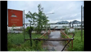
6. Floods force closure of Bhavani Island
GS PAPER I: GEOGRAPHY -Geographical Features & Their Location
CONTEXT: Flood discharges at Prakasam Barrage on the Krishna River have led to the closure of Bhavani Island from the mainland, impacting tourism activities and local revenue.
About Bhavani Island
- Location: Situated on the Krishna River near Vijayawada, Andhra Pradesh.
- Size: Spans around 133 acres, one of India’s largest river islands.
- Management: Run by Andhra Pradesh Tourism Department as a key eco-tourism and recreational site.
- Access: Located upstream of Prakasam Barrage, accessible only by ferry.
- Features: Lush greenery, ponds, boating, gardens, adventure parks, rural museums, and event venues.
- Cultural Significance: Named after Goddess Bhavani (Kanaka Durga), with her temple overlooking the river on Indrakeeladri Hill.
About Krishna River
- Significance: Major peninsular river stretching about 1,400 km.
- Course: Originates near Mahabaleshwar (Maharashtra) and flows east through Karnataka, Telangana, Andhra Pradesh into Bay of Bengal.
- Basin: Covers approx. 2.59 lakh sq km, ~8% of India’s area.
- Tributaries: Right bank includes Ghataprabha, Malaprabha; left bank includes Bhima, Koyna.
- Projects: Major dams include Almatti, Srisailam, Nagarjuna Sagar, Narayanpur, Jurala.
- Prakasam Barrage: Regulates flow near Vijayawada for irrigation, navigation, and tourism.
- Economic Role: Supports agriculture, fisheries, power generation; backbone of southern India’s river systems.
Flood Impact
- Floods from successive rains have caused high water releases at Prakasam Barrage, forcing Bhavani Island’s closure.
- Boating services suspended as boats cannot withstand strong flood currents beyond 1 lakh cusecs release level.
- Significant revenue loss to the tourism department due to suspension, especially during peak festival months.
- Flooding occurs due to cascading dam releases upstream and coinciding high tides causing waterlogging downstream.
7. KK Park cybercrime compound in Myawaddy township, Myanmar,
GS PAPER III: Security
Context: Around 500 Indian nationals who escaped the KK Park cybercrime compound in Myawaddy township, Myanmar, are being rescued by the Indian government, highlighting the growing crisis of transnational cybercrime and human trafficking in Southeast Asia.
About KK Park Cybercrime Hub 
- Location: Located in Myawaddy township, Karen State, Myanmar, near the Thailand border; originally a border trade zone turned cybercrime and human trafficking center.
- Control: Managed by the Border Guard Force under Saw Chit Thu, a junta-allied militia leader sanctioned by the U.S. Treasury.
- Operations: Functions as a “scam city” employing thousands in online fraud, crypto scams, and romance-investment schemes.
- Victimization: Victims recruited through fake overseas job offers, imprisoned, tortured, forced into cybercrimes after having passports confiscated.
- Scale: At peak, housed over 20,000 trafficked workers generating billions globally through scams.
- Structure: A self-contained enclave with dormitories, shops, armed security preventing escape.
Global Concern & UN Findings
- Identified by UNODC and GI-TOC as part of a network of scam compounds across Myanmar, Cambodia, a
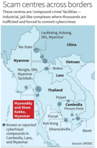 nd Laos.
- Cyber-scam economy earns over USD 10 billion annually, victimizing users in 110 countries.
- The 2025 Myanmar raid seized 30 Starlink terminals, criticized as cosmetic since main ringleaders evaded arrest.
- UN calls for cross-border enforcement, crypto tracking, victim rehabilitation, highlighting fusion of trafficking and transnational crime.
Impact on Indians
- India is both a source and target: hundreds trafficked under fake IT job offers.
- Since 2022, over 1,600 Indians repatriated, including 500 from KK Park in 2025 and 283 rescued from Thailand earlier by IAF.
- Rising crypto fraud, impersonation scams, digital extortion target Indian citizens.
- Government coordinates repatriation and strengthens cyber-diplomacy for broader regional anti-trafficking efforts.
8. The vision of Model Youth Gram Sabha
GS PAPER II: POLITY – Panchayats & Local Bodies
Why this is in the News
India has launched the Model Youth Gram Sabha (MYGS) initiative across 28 States and UTs to institutionalize youth participation in grassroots democratic governance through simulations linked with real Panchayati Raj processes.
About Model Youth Gram Sabha
- Constitutional Basis: Rooted in Article 243A (73rd Amendment) of Constitution, empowering local self-government through Gram Sabhas.
- Youth Focus: Designed to increase youth participation in grassroots governance, traditionally low among young voters.
Key Highlights of the Initiative
- Scale: Implemented in over 600 Jawahar Navodaya Vidyalayas and 2200 Kendriya Vidyalayas.
- Collaborative Effort: Ministry of Panchayati Raj, Ministry of Education, and Aspirational Bharat Collaborative jointly implement it.
- Curriculum Integration: Embedded simulations of Gram Sabha functioning in school education.
- Teacher Training: Special workshops train educators on Panchayati Raj processes and deliberation skills.
- Phased Rollout: Phase I targets schools across 28 States/UTs with future expansions planned.
Significance and Features
- Practical Democracy: Shifts civics education from theoretical to experiential, allowing students to simulate village budget discussions, planning, and governance.
- Nationwide Youth Engagement: Aims to train over 1,000 schools to nurture democratic values among rural and urban youth alike.
- UN-aligned Pedagogy: Incorporates participatory civic learning aligned with global democratic education standards.
- Leadership Development: Equips youth with skills in debate, negotiation, and consensus-building.
Expected Outcomes
- Civic Empowerment: Youth become aware of rights, duties, accountability, and policy nuances.
- Bridging Divide: Connects rural youth with governance, fostering inclusive, bottom-up democratic participation.
- Democratic Culture: Cultivates active citizenship and regular engagement with democratic processes from a young age.
Vision for Democratic Transformation
- Strengthens Institutions: Prepares future voters for effective involvement in Gram Sabha and Panchayati Raj institutions.
- Nurtures Leaders: Develops critical skills for democratic leadership.
- Restores Faith: Addresses political cynicism by linking theory with practice in governance.
- Future-ready India: Sustains democratic culture through engaged, informed future generations.